COC Long Distance (WRE)

Monday, August 4th
Black Magic Forest, Whistler
SCHEDULE
9:00 am: Registration desk open
9:45 am: First upload on the Wizard chair
10:30 am - 12:00 noon: Start times
Max time allowed: 180 minutes
3:00 pm: Course closes
1:30 pm: Awards at arena
MAP SNIPPET
Black Magic Forest, Whistler
SCHEDULE
9:00 am: Registration desk open
9:45 am: First upload on the Wizard chair
10:30 am - 12:00 noon: Start times
Max time allowed: 180 minutes
3:00 pm: Course closes
1:30 pm: Awards at arena
MAP SNIPPET
MAP INFO
Black Magic Forest
ISOM
Scale: 1:15,000 (M21, W21, M17-20, W17-20, M35-44, W35-44), 1:10,000 (others)
Contour Interval: 5 m
Size: 8.5" X 14"
Mapper: Erik Sundberg, 2013/2014 and Remo Madella 2014
Elevation: 900 m (approx)
Last major events: New map
OFFICIALS
Course planner: Brian Ellis, GVOC
Controller: Adrian Zissos, FWOC
IOF EVENT ADVISOR
Finn Arildsen, Denmark
ARENA INFORMATION
The arena is in the Upper Village, on the Blackcomb Mountain ski slopes, just above the base of the Wizard Chair. It will be a lively arena, with people travelling on the chair lift over head, the Family Adventure Zone amusement park just below, and many restaurants and shops close by.
Arena announcer: Magnus Johansson
Vendors: The O-Store will be in the arena for all your orienteering equipment needs.
Food: A light snack will be provided. Many coffee shops and restaurants are nearby.
Water: One drink of water will be provided at Finish. Please bring your own extra if needed.
Toilets: Flush toilets in the Blackcomb Day Lodge (go downstairs)
Family Adventure Zone: the arena is right next to this play ground which has many attractions including the Westcoaster slide, kiss the sky bungy trampoline, mini golf and many others. Plan to spend a bit of time there following the orienteering. There is a discount coupon in your race package - thanks to Whistler Blackcomb!
Directions to Arena & Start
See the overview map
The arena will be at the Upper Village. Plenty of free parking is available in the Day Lots, and it is also possible to walk here from Whistler Village.
To get to the start you must take the Wizard chairlift (ticket included in entry fee) and then walk downhill for approximately 15 - 20 minutes. Allow at least 30 minutes for this enjoyable journey, and longer if you are a slow downhill walker. The race, obviously, will have a net downhill.
Chairlift ticket
You must show your ticket to get on the chairlift. Your chairlift ticket can be used after the race to go up the mountain again for some sight-seeing and will give you access to all of the lifts, including the Peak2Peak. Write your name of the back and drop it off at the Start, then collect it at the Finish.
Clothes return
There will be a clothes return from the start to the finish. You can drop clothes in the bags at the start and they will be brought down to the arena periodically. We do not expect to make many trips, so do not rely on your clothes being at the arena when you finish.
Bad weather
The Wizard chair has an optional plexiglass cover that you can pull down to protect you from rain or cold.
Long event Start procedure
TRAIL-O
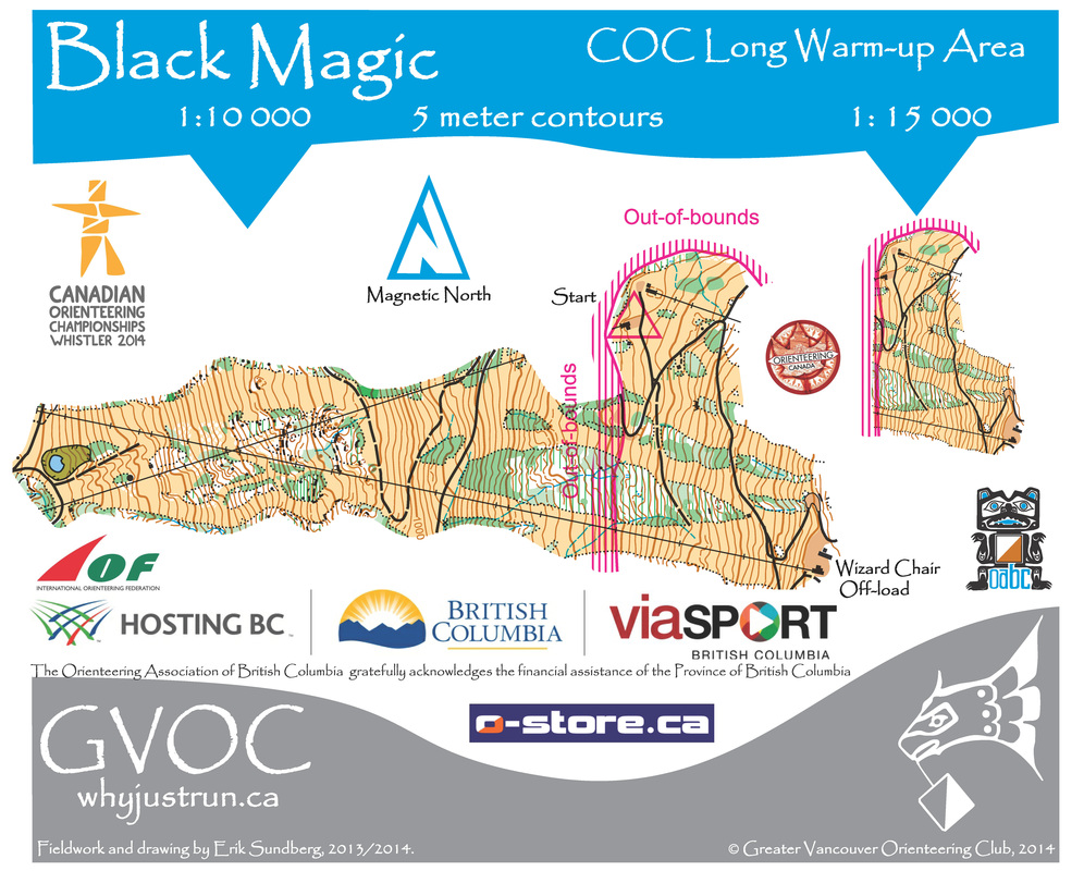
Trail-O is the fourth discipline of Orienteering, along with Foot-O, MTB-O and Ski-O. Today on the chair-lift to the start of the Long Distance Race you have the chance to try an unconventional and fun format of Trail-O.
On your warm-up map (you'll get one in your race package) you'll find seven Trail-O control points: from the chair-lift you have to look down and say if at each of the control points there is a flag (answer A), or there is no flag (answer Z).. A typical Z answer is when the flag is on a nearby similar feature, or on the correct feature but control description would say northern side but the flag is e.g. on southern side of the feature.
You will enter the map area after some minutes from the start of the chair-lift: check the pond on your right-hand side to know when you are in.
Leave your answer-sheet/warm-up map filled with your name and answers at the box at the start of the Long Race for a chance to win a prize. Five winners will be picked up randomly from all competitors with all correct answers. Prizes given out during the Long Distance awards.
You'll need to take a pencil with you for answering.
Course-setter of the TrailO is one of our 2014 mappers Remo Madella, member of the Italian Trail-O National Team.
RACE NOTES
Water on course
There will be water on all but the shortest courses, provided approximately every 25 minutes at the speed of the fastest runner on the course. Water will be taken from the creeks and purified using tablets. If it is very hot we recommend that you consider carrying your own water,
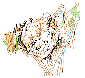
Creek crossings, marked routes & untimed legs - M20, M21, M35, M45, M55, W21, Open Expert
Classes on the longer courses will have one (M20, M35, M45, M55, W21, Open Expert) or two (M21) difficult creeks to cross (in both directions). These creeks have steep & dangerous banks in most places. Therefore we have taken the extraordinary measure of using mandatory marked routes to guide runners safely across. These routes will have controls at both ends and will be clearly identified both on the map and on the control descriptions.
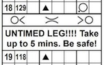
One of these creek crossings (for M20, M21, M35, M45, M55, W21 & Open Expert) is particularly difficult because of a steep downhill to the creek. For safety reasons it is decided that this leg (and this leg only) WILL NOT BE TIMED. You will be allowed to take up to five minutes to cross the creek (while we believe that 5 minutes is more than enough time to safely cross this marked route, competitors who do take longer than 5 minutes will have that excess time added on to their competition time). This crossing is clearly identified in the control descriptions. Please - take your time, and be very careful on this leg. Also note there will be purified water available at this creek crossing. Below are two snippets showing an example of what this will look like on your control descriptions & map (note: these are from an draft course and will not necessarily match exactly the control number or control description)
Black Magic Forest
ISOM
Scale: 1:15,000 (M21, W21, M17-20, W17-20, M35-44, W35-44), 1:10,000 (others)
Contour Interval: 5 m
Size: 8.5" X 14"
Mapper: Erik Sundberg, 2013/2014 and Remo Madella 2014
Elevation: 900 m (approx)
Last major events: New map
OFFICIALS
Course planner: Brian Ellis, GVOC
Controller: Adrian Zissos, FWOC
IOF EVENT ADVISOR
Finn Arildsen, Denmark
ARENA INFORMATION
The arena is in the Upper Village, on the Blackcomb Mountain ski slopes, just above the base of the Wizard Chair. It will be a lively arena, with people travelling on the chair lift over head, the Family Adventure Zone amusement park just below, and many restaurants and shops close by.
Arena announcer: Magnus Johansson
Vendors: The O-Store will be in the arena for all your orienteering equipment needs.
Food: A light snack will be provided. Many coffee shops and restaurants are nearby.
Water: One drink of water will be provided at Finish. Please bring your own extra if needed.
Toilets: Flush toilets in the Blackcomb Day Lodge (go downstairs)
Family Adventure Zone: the arena is right next to this play ground which has many attractions including the Westcoaster slide, kiss the sky bungy trampoline, mini golf and many others. Plan to spend a bit of time there following the orienteering. There is a discount coupon in your race package - thanks to Whistler Blackcomb!
Directions to Arena & Start
See the overview map
The arena will be at the Upper Village. Plenty of free parking is available in the Day Lots, and it is also possible to walk here from Whistler Village.
To get to the start you must take the Wizard chairlift (ticket included in entry fee) and then walk downhill for approximately 15 - 20 minutes. Allow at least 30 minutes for this enjoyable journey, and longer if you are a slow downhill walker. The race, obviously, will have a net downhill.
Chairlift ticket
You must show your ticket to get on the chairlift. Your chairlift ticket can be used after the race to go up the mountain again for some sight-seeing and will give you access to all of the lifts, including the Peak2Peak. Write your name of the back and drop it off at the Start, then collect it at the Finish.
Clothes return
There will be a clothes return from the start to the finish. You can drop clothes in the bags at the start and they will be brought down to the arena periodically. We do not expect to make many trips, so do not rely on your clothes being at the arena when you finish.
Bad weather
The Wizard chair has an optional plexiglass cover that you can pull down to protect you from rain or cold.
Long event Start procedure
- All competitors will be taken up the mountain on the Wizard Express chairlift. After unloading from the chairlift, please follow signs and flagging down the obvious road through several switchbacks to reach the Start, which is located at the top of the Excalibur gondola lift. Walking this distance at an easy pace will take you about 15 minutes. Reminder: there are no toilet facilities at the Start.
- After picking up their map at the 3-minute start line, each competitor will have to follow a flagged route that leads them to the site of the start triangle shown on their map. The Long event is using three different start triangles, so it is important to pay attention to the signage at the map boxes indicating which competitor classes are being directed to each of the start triangles. Each of the three flagged routes will also be marked with its own colour of flagging/pin flags.
TRAIL-O
Trail-O is the fourth discipline of Orienteering, along with Foot-O, MTB-O and Ski-O. Today on the chair-lift to the start of the Long Distance Race you have the chance to try an unconventional and fun format of Trail-O.
On your warm-up map (you'll get one in your race package) you'll find seven Trail-O control points: from the chair-lift you have to look down and say if at each of the control points there is a flag (answer A), or there is no flag (answer Z).. A typical Z answer is when the flag is on a nearby similar feature, or on the correct feature but control description would say northern side but the flag is e.g. on southern side of the feature.
You will enter the map area after some minutes from the start of the chair-lift: check the pond on your right-hand side to know when you are in.
Leave your answer-sheet/warm-up map filled with your name and answers at the box at the start of the Long Race for a chance to win a prize. Five winners will be picked up randomly from all competitors with all correct answers. Prizes given out during the Long Distance awards.
You'll need to take a pencil with you for answering.
Course-setter of the TrailO is one of our 2014 mappers Remo Madella, member of the Italian Trail-O National Team.
RACE NOTES
Water on course
There will be water on all but the shortest courses, provided approximately every 25 minutes at the speed of the fastest runner on the course. Water will be taken from the creeks and purified using tablets. If it is very hot we recommend that you consider carrying your own water,
Creek crossings, marked routes & untimed legs - M20, M21, M35, M45, M55, W21, Open Expert
Classes on the longer courses will have one (M20, M35, M45, M55, W21, Open Expert) or two (M21) difficult creeks to cross (in both directions). These creeks have steep & dangerous banks in most places. Therefore we have taken the extraordinary measure of using mandatory marked routes to guide runners safely across. These routes will have controls at both ends and will be clearly identified both on the map and on the control descriptions.
One of these creek crossings (for M20, M21, M35, M45, M55, W21 & Open Expert) is particularly difficult because of a steep downhill to the creek. For safety reasons it is decided that this leg (and this leg only) WILL NOT BE TIMED. You will be allowed to take up to five minutes to cross the creek (while we believe that 5 minutes is more than enough time to safely cross this marked route, competitors who do take longer than 5 minutes will have that excess time added on to their competition time). This crossing is clearly identified in the control descriptions. Please - take your time, and be very careful on this leg. Also note there will be purified water available at this creek crossing. Below are two snippets showing an example of what this will look like on your control descriptions & map (note: these are from an draft course and will not necessarily match exactly the control number or control description)

WRE NOTES
A reminder for all competitors on the M21 & W21 classes that IOF Competition Rules apply and that these rules forbid the use of GPS devices unless there is “no display or audible feedback”.
IOF Rules also require that the size of the control descriptions available at the pre-start is specified:
M21: 18cm X 4cm
W21: 13cm X 4cm
TERRAIN PHOTOS
COURSE PLANNER'S NOTES
Overview
The COC2014 Long event will be held on a new map (“Black Magic”) located on the lower slopes of Blackcomb Mountain. Blackcomb, the sister peak to Whistler Mountain, is a major ski centre in its own right, and one end of the “Black Magic” map includes portions of several ski runs and three lift systems.
This is an extraordinary area for orienteering. The landscape is wild and varied – from flower-strewn grassy ski slopes to deep West Coast mossy glens dominated by massive cliff systems. The overall topography is intricate, with many rock features on all scales, but the mapping is superb and consistent. Since all courses will start near the top of one of the ski lifts, and finish near the bottom station, competitors will be contending with a net descent of at least 300m. Within the forest area, the map includes a limited network of mountain bike trails, and these are readily recognized in the terrain.
Beyond the open ski slopes, the forest cover ranges from large tracts of mature coastal conifers (mapped as white) to smaller patches of recently logged terrain (mapped as dark green). The margins of the ski runs are also often thick with debris from the original clearing of the runs. The undergrowth in the mature forest tends to be sparse, but some local areas are impacted by windfall, or by stands of small fir trees whose density can slow progress and reduce visibility. Keep in mind that this is not a groomed forest – it definitely feels like a West Coast mountainside. Aside from the canopy of magnificent trees, the most distinctive vegetation in the forest is the carpet of emerald green moss that covers much of the ground. That lovely moss covering the ground can sometimes hide areas of broken rock, particularly around the base of cliffs and rockfaces, so watch your footing. Either orienteering shoes with spikes, or aggressive-tread trail shoes are strongly recommended.
Visibility in the terrain varies but is generally good, and runnability is similarly variable, but seldom really fast. Thus, while the course lengths may appear short by Championship standards, they have been designed to meet the Recommended Winning Time criteria for each class.
There are a number of smaller water features (ponds, small marshes) on the map, although many of them will be dry by August. The dominant water features are two major creeks that cut through the terrain. Both creeks have created canyons running down the mountainside, and can therefore only be crossed safely at a limited number of points. In each creek the streambed itself is typically clogged with timber and rocks, broken with pools and small waterfalls, and bordered by high cliffs and/or very steep earth banks, particularly in the lower reaches.
Hazards
Vegetation - There are no brambles, poison ivy or salal to deal with in the Black Magic terrain, but wet areas (small marshes and creek bottoms) often have some Devil’s Club growing in them. This distinctive broad-leafed shrub has long thin spines along its stem, which can be painful if you mistakenly grab the stem. However, they are not barbed or toxic, and it is generally not problematic to simply run through a patch of Devil’s Club.
Rock features - The mapper has been rigorous in his definition of boulders (always large and distinct), rock faces (essentially vertical and at least 2 metres high) and cliffs (truly awesome!). Since the rock faces and cliffs are perched on a mountain slope, you will often be approaching them from above. Do so cautiously, and do NOT attempt to directly descend cliffs or rock faces.
Animals - Black bears frequent the Whistler/Blackcomb area, and have occasionally been seen in the mapped area, both on the ski runs and in the forest. They are quite habituated to humans but will usually avoid close contact, given the chance. If you encounter a bear along your course, make them aware of your presence with loud noise and gestures. If the bear doesn’t leave the area, you may want to carefully back away and abandon the course. The mapper did encounter one cougar during his many days in the terrain, but this is a very rare event. Again, if you should happen to encounter one, and it doesn’t immediately run off, consider backing away carefully and abandoning your course. Any encounters with large animals should be reported to the Finish Chief at the arena.
There will be mosquitos (this is Canada).
Stream crossings - Longer courses will need to cross one or both of the major creeks described above. If you cross a creek on your outbound trip, you will also do so on your return, but not necessarily at the same point. As noted above, all parts of both creeks other than the designated crossing points are hazardous to cross, and out of bounds. Each stream crossing on a given course has been flagged in the terrain (pink flagging) leading from the nearest control on one side of the stream to the nearest control on the other side. The more agile might find a way across the stream itself without getting their feet wet; otherwise, you can expect to wade for 2-3 metres in fast-running water 20-30 cm deep. Watch your footing!
One of the stream crossings requires descending a very steep slope to reach the stream. A suitable route has been flagged down this slope, and there are trees to serve as handholds, but extreme care should be taken to avoid slipping. We don’t want anyone to feel rushed at this point, so the time required to complete this particular crossing will not be counted as part of your race time.
Traffic – There is a major unpaved service road crossing the upper Wizard Chair ski runs (mapped as a solid black road). This is used by Whistler/Blackcomb mountain staff to move things up and down the mountain and it can sometimes have heavy trucks travelling along it. Our access permission allows for runners to cross this road, with due attention to any traffic, but forbids walking/running along it during your course. The roads mapped as heavy dashed lines on the ski runs are not restricted, but there are occasionally ATV convoys travelling along these, so keep your eyes (and ears) open.
The mountain bike trails in the forest are actively, but not heavily, used. Watch for riders when you are travelling along them; they may not be expecting pedestrians! These trails can sometimes drop down the fall-line at a remarkable angle, so be careful of your footing when following them in the steeper areas.
Safety bearings and abandoning the course – If you become lost, your safest exit is downhill (west), since most of the map is bordered on the west side with service roads and a golf course. The traveling may not always be easy, especially if you find yourself in one of the logging slash zones. The safest exits are probably along mountain bike trails, since these will ultimately go to the valley bottom. If you travel downhill parallel to either of the two major creeks, it is safest to follow them by sound; do NOT attempt to get into the canyon. At the foot of the slope (west side of the map) you will eventually reach a road, and you can follow these roads south to return to Whistler (Upper) Village, the ski area and the arena. There is good cell phone coverage on all parts of the map, for those interested in carrying one.
WARMUP MAP
The warm-up map shows the area below the chairlift as you ride up to the start plus a small amount of the open slopes and tracks that you must walk down from the top of the Wizard Chair to the race start. The warm-up map will be distributed in your race package.